GIS Application in Urban Traffic Air Pollution Exposure Study: A Research Review
Keywords:
Dispersion, Pollution Exposure, GIS Application, Urban Air Quality, Vehicular EmissionAbstract
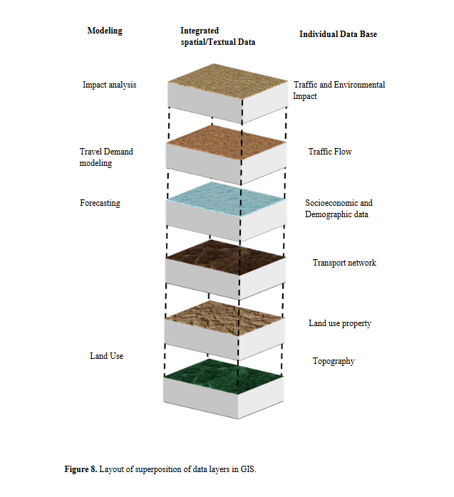
This paper reports a preliminary study of the evaluation and forecast of transport-related air pollution dispersion in urban areas with the help of Geographic Information System (GIS) platform and a simulative system with graphical inter- face. The urban population growth, economic development, energy consumption, growing transportation demand and living standards play major role in pollution exposure in atmosphere. A lot of research has already been done to investigate the functional relationship between air quality and air pollution from transport. This study is an effort to develop a more flexible framework of model to find the
exposure of the air pollution in the atmosphere. This review article describes the development of framework of different GIS inputs that help to find the exposure of vehicular pollution in megacity.
References
Amato, G. D., Cecchi, L., Amato, M. D. & Liccardi, G. (2010). Urban air pollution and climate change as environmental risk factors of respiratory allergy an update.Journal of Investigational Allergology and Clinical Immunology, 20(2), 95-102.
Batterman, S., Chambliss, S. & Isakov, V.(2014). Spatial resolution requirements for traffic-related air pollutant exposure evaluations Atmospheric Environment, 94,518-528.
Behera, S. N., Sharma, M., Dikshit, O. & Shukla, S. P. (2011). GIS-based emission inventory, dispersion modeling, and assessment for source contributions of particulate matter in an urban environment.Water Air Soil Pollution, 218, 423-436.
Borrego, C., Tchepel, O. & Costa, A. M.(2006). Traffic-related particulate air pollution expo- sure in urban areas. Atmospheric
Environment, 40, 7205-7214.
Brunsdon, C., Fotheringham, A. S. & Charlton,M. E. (1996). Geographically weighted regression: A method for exploring spatial
non stationarity. Geographical Analysis, 28(4),281-298.
Central Pollution Control Board (CPCB) Annual Report 2011-2012. (2012). Dehli: Central Pollution Control Board.
Das, A. & Parikh, J. (2004). Transport scenarios in two metropolitan cities in India: Dehli and Mumbai. Energy Conversion and Manage-
ment, 45, 2603-2625.
David, J., Briggs, S. C. & Paul, E. (1997).Mapping urban pollution using GIS: A regression-based approach. International Journal of Geographical Information Science,11, 699-718.
Elbir, T. (2004). A GIS based decision support system for estimation, visualization and analysis of air pollution for large Turkish
cities. Atmospheric Environment, 38, 4509-4517.
Elliott, P. & Wartenberg, D. (1997). Spatial epi-demicology current approaches and future challenges. Environmental Health Perspec-
tives, 105(6): 598-605.
Faiz, A., Weaver, S. W. & Walsh, M. P. (1996).Air Pollution from Motor Vehicles: Standards and Technologies for Controlling Emissions.
Washington, D.C: The World Bank.
Gerard, H., Rob, B. & de Hoogh, K. (2008). A re-view of land-use regression models to assess spatial variation of outdoor air pollution,
Atmospheric Environment, 42, 7561-7578.
Gulliver, J. & Briggs, D. ( 2011). STEMS-Air:A simple GIS-based air pollution dispersion model for city-wide exposure assessment.
Science of the Total Environment, 409, 2419-2429.
Gulliver, J., & Briggs, D. J. (2005). Time-space modeling of journey-time exposure to traffic-related air pollution using GIS. Environmental
Research, 97, 10-25.
Gurjar, B. R., Aardennea, V. J. A., Lelievelda, J. & Mohan, M. (2004). Emission estimates and trends (1990-2000) for megacity Delhi and
implications. Atmospheric Environment, 38,5663-5681.
Gurjar, B.R., & Lelieveld, J. (2005). New Direc-tions: Megacities and global change. Atmos-pheric Environment, 39(2), 391-393.
Gurjar B.R., Butler, T. M., Lawrence, M. G. & Lelieveld, J. ( 2008). Evaluation of emissions and air quality in megacities. Atmospheric
Environment, 42, 1593-1606.
Guttikunda, S. K. & Bhola, R. G. ( 2012). Role of meteorology in seasonality of air pollution in megacity Delhi, India Environmental Moni-
toring and Assessment, 184(5), 3199-3211.
Guttikunda, S. K., Tang, Y. H., Carmichael, G. R.,Kurata, G., Pan, L., Streets, D. G., Woo, J. H., Thongboonchoo, N. & Fried, A. (2001).
Impacts of asian megacity emissions on regional air quality during spring. Journal of Geophysical Research, 110(D20), 1-18.
Guttikunda, S. K., Calori, G. (2013). A GIS based emissions inventory at 1KM X 1KM spatial resolution for air pollution analysis in Delhi
India. Atmospheric Environment, 67, 101-111.
Hammond D., Conlon, K., Barzyk, T., Chahine, T., Zartarian, V. & Schultz, B. (2011). Assessment and application of national environmental
databases and mapping tools at the local level to two community case studies. Risk Analysis Journal, 31, 43-53.
Huo, H., Zhang, Q., He, K., Yao, Z., Wang, X., Zheng B., Streets, D. G., Wang, Q., & Ding, Y. (2011). Modeling vehicle emissions in
different types of Chinese cities: Importance of vehicle fleet and local features. Environmental Pollution, 159, 2954-2960.
Min, D.L. & Yung, C. L. ( 2002). The application of GIS to air quality analysis in Taichung City, Taiwan, ROC, Environmental Modeling
& Software, 17, 11-19.
National Ambient Air Quality Standards (2012).Report of national ambient air quality monitoring 2011-2012. Ohio: USEPA.
Nagpure, A.S., Sharma, K. & Gurjar, B. R.(2013). Traffic induced emission estimates and trends (2000–2005) in megacity Delhi.
Urban Climate, 4, 61-73.
Nuckols, J. R., Ward, M. H. & Jarup, L. (2004).Using geographic information systems for exposure assessment in environmental epide-
micological studies. Environmental Health Perspective, 112, 1007-1015.
Onursal, B. & Gautnam, S. P. (1997). Vehicle air pollution: experiences from seven Latin American urban centers, Technical paper No.
Washington D.C.: World Bank.
Pant, P. & Roy, M. ( 2012). Harrison critical review of receptor modeling for particulate matter: a case study of India. Atmospheric
Environment, 49, 1-12.
Richards, M., Ghanem, M. & Osmond, M. (2006).Grid-based analysis of air pollution data.Ecological Modeling, 194(1): 274-286.
Rytkonen, M. J. (2004). Not all maps are equal GIS and special analysis in epidemiology.International Journal of Circumpolar Health,
(1), 9-24.
Sahzabi, A. Y., Sasaki, K., Yousefi, H., Pirasteh, S. & Sugai, Y. (2011). GIS aided prediction of CO2 emission dispersion from geothermal
electricity production. Journal of Cleaner Production, 19, 1982-1993.
Scoggins A, Kjellstrom, T., Fisher, G., Connor J.& Gimson N. (2004). Spatial analysis of annual air pollution exposure and mortality.
Science of the Total Environment, 321, 71-85.
Sutanto, S. & Erni, S. T. (2005). Study on corre-lation between motor vehicle emission and public health, Eastern Asia Society for
Transportation Studies, 5, 1841-1856.
Tiwary, A & Colls J. (2010). Air Pollution: Mea-surement, Modeling & Mitigation (Third edition.). Abingdon, Oxon, UK: Routledge
Taylor & Francis Group.
United States Environmental Protection Agency (2012). AERMOD Evaluations Under the 1-hour NO2 and SO2 NAAQS. Retrieved from
United State Environmental Protection Agency (2010). Air Quality Index (AQI) - A Guide to Air Quality and Your Health. Retrieved from
Vine, M. F., Degnan, D. & Hanchette, C.(1997). Geographic information systems:their use in environmental epidemiologic
research Envi- ronmental HealthPerspective, 105(6), 598-605.
Whitelegg, J. & Haq, G. (2003). The global trans-port problem: some issues but a different Place (in John World Transport, Policy
and Practice). London: Earth scan publications limited.
World Health Organization. (2014). Air quality and health. Retrieved from http://www.who.int/
World Health Organization (2011). Air quality and Health. Report 2011. Retrieved from http://www. who.int/
World Health Organization. (2012). Air quality and health. Retrieved from http://www.who.int/mediacentre/factsheets/fs313/en/index.html
Yang, K, Man, C. & Zhen, C. (2009). Urban air pollution study based on GIS. Nanjing: IEEE