Spatial Distribution of Crimes Against Property: A Case Study in Nakhon Pathom Province
DOI:
https://doi.org/10.53848/ssstj.v10i2.434Keywords:
Crimes against property, Geo-statistic analysis, Moral’s I, Getis-Ord Gi, Standard deviational ellipseAbstract
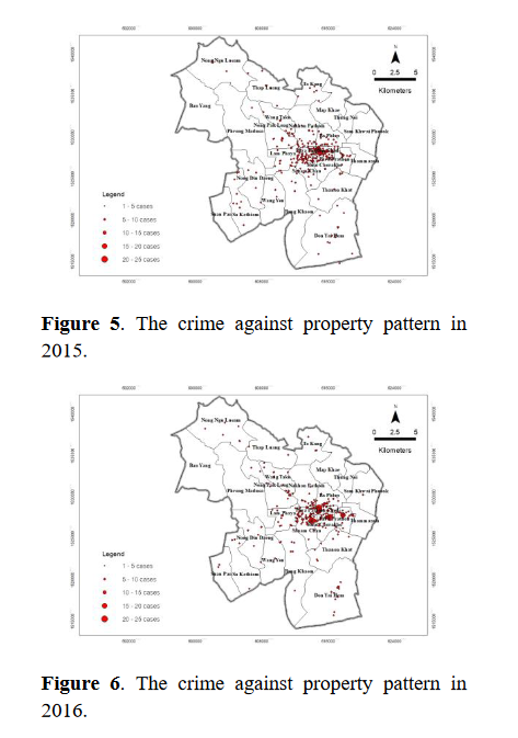
Crimes against property were correlated with the recession of the economy. According to the Royal Thai Police report, crimes against property continue to increase. The criminal statistics showed that the second-highest number of crimes against property was found in Nakhon Pathom Province. The purposes of this study were to 1) examine the pattern of crimes against property using Moran’s I, 2) investigate the spatial distribution of crimes against property using Getis-Ord Gi*, 3) find out the directional distribution of crimes against property using a standard deviational ellipse, and 4) explore the spatial relationship between crimes against property, land use, and population density. Secondary data on crime cases were collected from the Mueang Nakhon Pathom Police Station criminal report book between 2013 and 2018 and then converted to spatial data. The results of the study were as follows: 1) The pattern of the cases over 5 years was clustered; 2) the spatial distribution of cases revealed hotspot areas with a GiZscore greater than 1.65 over 5 years covering residential and village areas, city and town areas, commercial areas, entertainment venues, local education institutes, the boulevard, dark alleys, and deserted streets; 3) the directional distribution of the cases over 5 years was distributed to the west of the study area; and 4) urban and built-up land was discovered where most cases occurred. Overall, the crimes against property clustered around crowded residential areas and villages, dark alleys, and deserted streets. This study facilitates investigations, defense, and control of crimes against property.
References
Abdulhafedh, A. (2017). A novel hybrid method for measuring the spatial autocorrelation of vehicular crashes: Combining Moran’s Index and Getis-Ord Gi* statistic. Open Journal of Civil Engineering, 7(2), 208-221.doi:10.4236/ojce.2017.72013
Achu, A. L., Aju, C. D., Suresh, V., Manoharan, T.P., & Reghunath, R. (2019). Spatio‑temporal analysis of road accident incidents and delineation of hotspots using geospatial tools in Thrissur district, Kerala, India. KN -Journal of Cartography and Geographic Information, 69, 255-265.doi:10.1007/s42489-019-00031-1
Ahmed, M., & Salihu, R. (2013). Spatiotemporal pattern of crime using Geographic Information System (GIS) approach in Dala L.G.A of Kano State, Nigeria. American Journal of Engineering Research (AJER), 2(3), 51-58.
Balogun, T. F., Okeke, H., Chukwukere, C. I.(2014). Crime mapping in Nigeria using GIS. Journal of Geographic Information System,6(5), 453-466. doi:10.4236/jgis.2014.65039
Chutia, D., Santra, M., Nishant, N., Singh, P. S.,Chouhan, A., & Raju, P. L. N. (2020).Mapping of crime incidences and hotspot analysis through incremental auto correlation– A case study of Shillong city, Meghalaya,India. Journal of Geomatics, 14(1), 61-71.
Dechsiri, B., & Robert, O. P. (2019). Drug trafficking estimation based on geo-statistics.Defence Technology Academic Journal, 1(3),52-61.
Dharmniti. (2019). Against property according to the Criminal Code. Retrieved from https://www.dharmniti.co.th/
ESRI. (2009a). How spatial autocorrelation (global Moran's I) works. Retrieved from https://www.pro.arcgis.com/
ESRI. (2009b). How hot spot analysis (Getis-Ord Gi*) works. Retrieved from https://www.pro.arcgis.com/.
ESRI. (2009c). Standard deviational ellipse (Spatial statistics). Retrieved from https://pro.arcgis.com/en/
In-ain, T. (2018). Developing a spatial database for the application of GIS in drug offences analysis. Retrieved from https://www.agi.nu.ac.th/nred/Document/is-PDF/2561/geo_2561_018_FullPaper.pdf
Mitchell, A. (2005). The ESRI guide to GIS analysis, volume 2: Spatial measurements and statistics. Retrieved from https://www.esri.com/en-us/esri-press/
Mohammed, A. F., & Baiee, W. R. (2020).Analysis of criminal spatial events in GIS for predicting hotspots. IOP Conference Series:Materials Science and Engineering, 928, 1-8.doi:10.1088/1757- 899X/928/3/032071
National Statistical Office. (2011). Top 10 statistics. Retrieved from http://service.nso.go.th /nso/nsopublish/TopTen/Top_othsoc.html
Nation Statistical Office. (2016). Statistics of reported and arrested for the crimes of interest group by type of reported cases and province: 2007-2016. Retrieved from http://statbbi.nso.go.th/staticreport/
Paramasivam, C. R., & Venkatramanan, S. (2019).An introduction to various spatial analysis techniques. In S. Venkatramanan, M. V.Prasanna, & S. Y. Chung (Eds.), GIS and geostatistical techniques for groundwater science (pp. 23-30). Amsterdam, Netherlands:Elsevier.
Phuaksomon, K. (2020). People participation in preventing crimes in Hatyai Municipality, Hatyai District, Songkhla Province (Master’s thesis). Kasetsart University, Thailand.
Prasannakumar, V., Vijith, H., Charutha, R., & Geetha, N. (2011). Spatio-temporal clustering of road accidents: GIS based analysis and assessment. Procedia - Social and Behavioral Sciences, 21, 317-325. doi:10.1016/j.sbspro.2011.07.020
Rattanapongs, P., & Gulabutr, V. (2020). Safety management from crime: against properties of students living dormitories in Salaya district, Nakhon Pathom Province. Journal of MCU Buddhapanya Review, 5(3), 114-129.
Royal Thai Police. (2021). Cracking down on the crime problem in 2011, escalating non-stop,social threats aggravate the people during the Covid period. Retrieved from https://www.thairath.co.th/scoop/theissue/226-2011
Srithamarong, T. (2016). Crime risk area assessment based geo-spatial statistics (Master’s thesis, Silpakorn University).Retrieved from http://www.sure.su.ac.th/xmlui/handle/123456789/20686
Thailand Lawyer. (2020). Criminal code. Retrieved from https://library.siam-legal.com/thai-law
Wang, B., Shi, W., & Miao, Z. (2015). Confidenceanalysis of standard deviational ellipse andits extension into higher dimensional Euclidean space. PLoS ONE, 10(3).doi:10.1371/journal.pone.0118537
Yiampisan, M., & Srivanit, M. (2010). Using the Kernel density estimation surface for criminal pattern: A case study in Phranakhon District,Bangkok. Journal of Architectural/Planning Research and Studies, 7(1), 87-102.
Downloads
Published
How to Cite
Issue
Section
License
Copyright (c) 2023 Suan Sunandha Rajabhat University

This work is licensed under a Creative Commons Attribution 4.0 International License.