Mapping Land Cover Dynamics in Nakhon Nayok Province of Thailand
Keywords:
Remote sensing, Landsat, Land cover dynamics, Change detectionAbstract
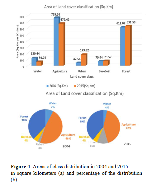
The spatial distribution of land cover information and its changes is very valuable for any planning, management and monitoring at local as well as regional scale. In this paper, multi-temporal Landsat TM/ OLI data were used to classify the land cover of the Nakhon Nayok province in Thailand over the period 2004-2015. The supervised classification maximum likelihood method was implemented to assign probability to land the cover classes considered. The random sampling point method was used for field survey and accuracy assessment. The overall accuracy and kappa coefficient in 2015 were found to be 72% and 0.6626 respectively. The results also indicated that important changes concerned mainly urban (308.46 %), water (-50.46%), and agricultural (-12.14%) areas, and least
changes forest areas (3.17%). These results also highlighted that over the last 10 years, urban areas have been characterized by the highest expansion, mainly from the conversion of agricultural land.
References
Bauer, M. E., Burk, T. E., Ek, A. R., Coppin, P. R., Lime, S.D., & Walters, D. K. (1994). Satellite inventory of minnesota forests. Photogrammetric Engineering and Remote Sensing. 60(3), 287-298.
Bruce, C. M. (2004). Pre-processing methodology for application to landsat TM/ETM+ imagery of the wet tropics. cooperative research centre for tropical rainforest ecology and management. Retrieved from http://www.rainforest.crc.jcu.edu.au/publications/landsat_preprocessing.pdf
Chander, G. B. (2003). Revised landsat-5 tm radiometric calibration procedures and postcalibration dynamic ranges. IEEE transactions on geoscience and remote sensing, 41, 2674-2677.
Chavez, P. S. (1988). An improved dark object subtraction technique for atmospheric scattering correction of multispectra data. Remote Sensing of Environment, 24, 459-479.
Diallo, Y., Hu, G., & Wen, X. (2009). Application of remote sensing in land use /land cover chnage detection in puer and simao cointries, yunnan province. Journal of American Science, 5(4), 157-166.
Fichera, C. R., Giuseppe M., & Maurizio, P. (2012). Land cover classification and change-detection analysis using multi-temporal remote sensed imagery and landscape metrics. European Journal of Remote Sensing, 45, 1-18.doi: 10.5721/EuJRS20124501.
Furkuo, E. K., & Frimpong, A. (2012). Analysis of forest cover change detection. International Journal of Remote Sensing Applications, 2(4), 82-92.
Hames, F. S., & Al-Ahmadi, A. S. (2008). Comparison of four classification methods to extract land use and land cover from raw satellite images for some remote arid areas, Kingdom of Saudi Arabia. Journal of King Abdulaziz Unuversity Earth Sciences, 20(1), 167-191.(2009 A.D./1430 A.H.).
Hames, F. S., & Al-Ahmadi, A. S. (2009). Comparison of four classification methods to extract land use and land cover from raw satellite images for some remote arid areas, Kingdom of Saudi Arabia. Journal of King Abdulaziz Unuversity Earth Sciences, 20 (1), 167-191.
Lu, D., Mausel, P., Batistella, M., & Moran, E. (2004).Comparison of land-cover classification methods in the brazilian amazon basin.
Photogrammetric engineering & remote sensing, 70(6), 723-731.
McIver, D. K., & Friedl, M. A. (2002). Using prior probabilities in decision-tree classification of remotely sensed data. Remote Sensing of Environment, 81, 253-261.
Mengistu, D. A., & Salami, A. T. (2007). Application of remote sensing and GIS inland use/land cover mapping and change detection in a part of south western Nigeria. African Journal of Environmental Science and Technology, 1(5), 99-109.
Musa, S. K. (2003). Assessing the status of logged-over production forests: the development of rapid appraisal technique. Retrieved from ftp://ftp.fao.org/docrep/fao/005/AC838E/AC838E00.pdf
Reis, S. (2008). Analyzing land use / land cover changes using remote sensign and GIS in Rize North-East Turkey. Sensors, 8, 6188-6202.
Rogan, J., Franklin, J., & Roberts, D. A. (2002). A comparision method for monitoring multitemporal vegetation changes using Thematic Mapper imagery. Remote Sensing Environmental, 80(1), 143-156.
Rokni, K., Ahmad, A., Selamat, A., & Hazini, S. (2014). Water feature extraction and change detection using multitemporal landsat imagery. Remote Sensing, 6, 4173-4189. doi:10.3390/rs6054173.
Szuster, B. W., Chen, Q., & Borger, M. (2011). A comparison of classification techniques to support land cover and land use analysis in tropical coastal zones. Applied Geography, 31(2), 525-532.
United State Geological Survey. (2015). Check lists of landsat 8 oli characteristics: 0431. Retrieved from http://www.landsat.usgs.gov.
Vittek, M., Brink, A., Donnay, F., Simonetti, D., & Desclée, B. (2014). Land cover change monitoring using landsat mss/tm satellite image data over west. Remote Sensing,6, 658-676. doi:10.3390/rs6010658.
Wu, W. & Shao, G. (2002). Optimal combinations of data, classifiers, and sampling methods for accurate characterizations of deforestation. Canadian Journal of Remote Sensing, 28(4): 601-609.
Yuan, F., Sawaya, K. E., Loeffelholz, B. C., & Bauer, M. E. (2005). Land cover classification and change analysis of the twin cities (minnesota) metropolitan area by multitemporal landsat remote sensing. Remote Sensing of Environment, 98 (2&3), 317-328.