Analysis of Land Use Changes with the Google Earth Engine (GEE) Platform: A Case Study in Saraburi Province
DOI:
https://doi.org/10.53848/ssstj.v11i2.820Keywords:
Land-use changes, Landsat satellite, Google Earth Engine, Sustainability, SaraburiAbstract
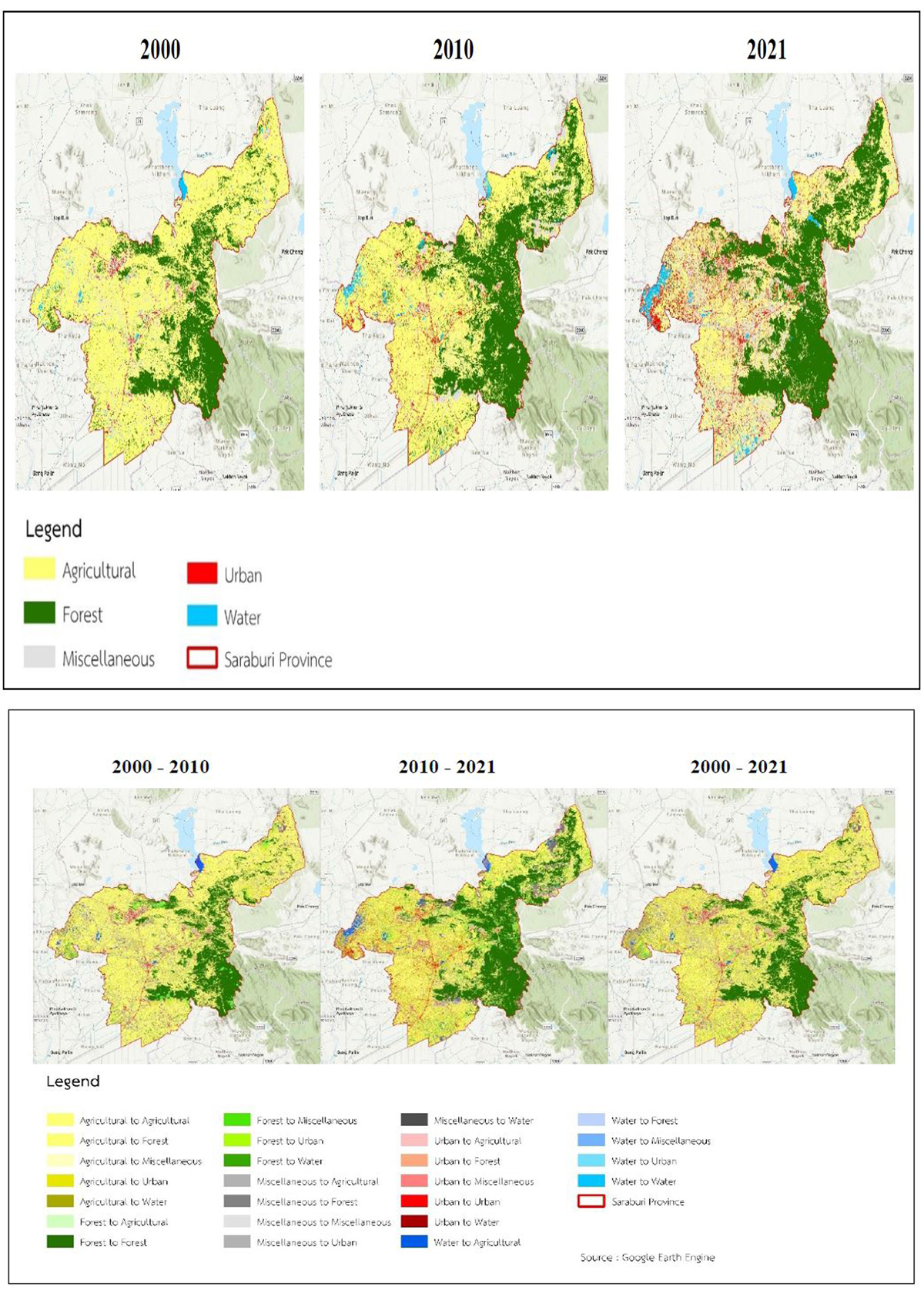
The increasing trend of industrial development has led to rapid changes in land use over the past few years. The changes in land use in Saraburi Province were studied during three periods: the years 2000, 2010, and 2021, using Landsat satellite imagery processed with the Google Earth Engine (GEE) platform. The Random Forest (RF) machine learning algorithm was employed to classify land use activities into five categories based on the criteria set by the Department of Land Development. The overall accuracy values for land use were 83.59%, 82.42%, and 80.78%, respectively. The changes in land use have clearly affected the urban and built-up area. In 2000, there were only 7,561.15 ha, but by 2021, the area had increased to 34,221.11 ha. Forest areas also saw an increase. In 2000, there were only 79,626.26 ha, which increased to 163,542.05 ha in 2021, reflecting that Saraburi Province places importance on green areas. In contrast, agricultural areas decreased, which was attributed to the increasing number of households, according to the statistical report from the Department of Provincial Administration. In 2000, there were 168,979 households, and by 2021, they had increased to 288,275 households, resulting in a change in land use from agricultural areas to urban and built-up areas, totaling 22,114.95 ha. This information can be used as a guideline for planning development and land use to promote Saraburi Province, aiming towards becoming an eco-industrial city that is livable and has sustainable environmental quality in the future.
References
Fitzpatrick-Lins, K. (1981). Comparison of sampling procedures and data analysis for a land-use and land-cover map. Photogrammetric Engineering and Remote Sensing, 47(3), 343-351.
Geo-Informatics and Space Technology Development Agency (Public Organization). (2009). Space technology
and geo-informatics. Bangkok, Thailand: Amarin Printing and Publishing Public Company.
Intarat, K. (2022). Land use classification in Nakhon Nayok Province using machine learning algorithms and Sentinel-2 image. Burapha Science Journal, 27(2), 1153-1171.
McHugh, M. L. (2012). Interrater reliability: the kappa statistic. Biochemia Medica, 22(3), 276-282.
Office of the National Economic and Social Development Board. (2017). The Twelfth National Economic and
Social Development Plan (2017-2021). Bangkok, Thailand: Office of the Prime Minister.
Pannon, S. (2018). Land use change and its impacts on water pumping in Bang Pakong River basin, Thailand (Master’s thesis). Asian Institute of Technology, Thailand.
Supatra, P., & Puttanawarat, N. (2021). Development of geographic information systems and spatial data
analysis. Faculty of Science and Technology, Prince of Songkhla University, Surat Thani Campus.
Downloads
Published
How to Cite
Issue
Section
License
Copyright (c) 2024 Suan Sunandha Rajabhat University

This work is licensed under a Creative Commons Attribution 4.0 International License.